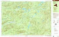
1997 Map of West Canada Lakes
USGS Topo · Published 1999About this map
Adirondack Park spans this 1990s topographic study, revealing a landscape defined by an intricate network of high-elevation glacial ponds and interconnected waterways. The central plateau is dominated by the West Lake and South Lake systems, which feed into the headwaters of the West Canada Creek Stillwater. Human presence is minimal and transient, represented by remote outposts like Millers Camp and a system of backcountry trails and a Footbridge that navigate the wetlands and summits.
Find a feature on this map
54 named features on this map. Tap any name to fly to it.
Don’t see what you’re looking for? This feature index may not catch every label — zoom into the map to look around manually.
Map Details
Editions of this 1997 West Canada Lakes Map
This is the sole edition of this map. No revisions or reprints were ever made.
Other maps of this area

1899 · Indian Lake
USGS Topo · 1:62,500

1900 · Canada Lake
USGS Topo · 1:62,500

1900 · Wilmurt
USGS Topo · 1:62,500

1901 · Old Forge
USGS Topo · 1:62,500

1902 · Wilmurt
USGS Topo · 1:62,500

1902 · Indian Lake
USGS Topo · 1:62,500

1903 · West Canada Lakes
USGS Topo · 1:62,500

1904 · Piseco Lake
USGS Topo · 1:62,500

1906 · Piseco Lake
USGS Topo · 1:62,500

1907 · Lake Pleasant
USGS Topo · 1:62,500