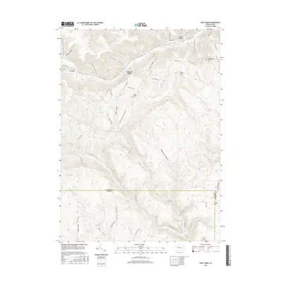
2016 Map of West Creek
USGS Topo · Published 2016About this map
The boundary between Cameron and Elk Counties bisects this landscape of deep hollows and narrow stream valleys. The primary settlement corridor follows West Creek along the northern edge, where Route 120 links the communities of Truman, Howard Siding, and the village of West Creek. This valley floor contrasts sharply with the dissected plateaus to the south, which are defined by a complex network of drainage systems including Hicks Run and Bell Draft.
Find a feature on this map
59 named features on this map. Tap any name to fly to it.
Don’t see what you’re looking for? This feature index may not catch every label — zoom into the map to look around manually.
Map Details
Editions of this 2016 West Creek Map
This is the sole edition of this map. No revisions or reprints were ever made.
Other maps of this area

1941 · Benezette
USGS Topo · 1:62,500

1943 · Benezette
USGS Topo · 1:62,500

1945 · Driftwood
USGS Topo · 1:48,000

1945 · Driftwood
USGS Topo · 1:24,000

1945 · Cameron
USGS Topo · 1:24,000

1947 · Cameron
USGS Topo · 1:24,000
1947 · Driftwood
USGS Topo · 1:24,000

1948 · Crosby
USGS Topo · 1:62,500

1948 · Emporium
USGS Topo · 1:62,500

1948 · Emporium
USGS Topo · 1:24,000
Featured Places
- Benezette Township, PA
- Gibson Township, PA
- Lumber Township, PA
- Shippen Township, PA
- Truman, Shippen Township