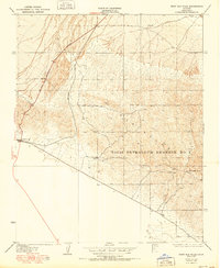
1950 Map of West Elk Hills
USGS Topo · Published 1950About this map
Naval Petroleum Reserve No 1 dominates this topographic study of Kern County, highlighting an era when strategic energy reserves shaped the California interior. The map illustrates a landscape transitioning from the open terrain of the Elk Hills to the industrial hubs of McKittrick and the settlement of Asphalto. This 1950 edition, based on earlier field surveys by E. P. Davis and C. A. Stonesifer, reveals the critical infrastructure supporting the region's petroleum extraction.
Find a feature on this map
7 named features on this map. Tap any name to fly to it.
Don’t see what you’re looking for? This feature index may not catch every label — zoom into the map to look around manually.
Map Details
Editions of this 1950 West Elk Hills Map
This is the sole edition of this map. No revisions or reprints were ever made.
Other maps of this area

1910 · Buena Vista Lake
USGS Topo · 1:125,000

1912 · McKittrick
USGS Topo · 1:125,000

1912 · Buena Vista Lake
USGS Topo · 1:125,000

1931 · Lokern
USGS Topo · 1:31,680

1932 · West Elk Hills
USGS Topo · 1:31,680

1932 · East Elk Hills
USGS Topo · 1:31,680
1932 · Buttonwillow
USGS Topo · 1:31,680

1934 · Lokern
USGS Topo · 1:31,680
1942 · Buttonwillow
USGS Topo · 1:62,500
1943 · Belridge
USGS Topo · 1:31,680