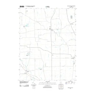
2010 Map of West Elkton
USGS Topo · Published 2010About this map
West Elkton serves as a central hub for this rural portion of Preble and Butler counties, defined by its Quaker heritage as evidenced by the Friends Cemetery. The landscape is a network of small agricultural settlements and family-named landmarks connected by a grid of historic roads like Wayne Trace Rd and Quaker Trace Rd. Several water bodies, including Rush Run Lake and Doughman Lake, interrupt the drainages of Elk Creek and Sevenmile Creek. To the south and east, the small communities of Collinsville, Jacksonburg, and Beechwood anchor their respective corners of the quadrangle. Genealogists will find numerous burial sites scattered across the township lines, from the Patterson Cemetery in the north to the Scott Cemetery near the southern border, providing a clear record of local family history.
Find a feature on this map
61 named features on this map. Tap any name to fly to it.
Don’t see what you’re looking for? This feature index may not catch every label — zoom into the map to look around manually.
Map Details
Editions of this 2010 West Elkton Map
This is the sole edition of this map. No revisions or reprints were ever made.
Other maps of this area

1904 · Mason
USGS Topo · 1:62,500

1906 · Mason
USGS Topo · 1:62,500

1908 · Miamisburg
USGS Topo · 1:62,500

1911 · Oxford
USGS Topo · 1:62,500

1915 · Hamilton
USGS Topo · 1:62,500

1917 · Hamilton
USGS Topo · 1:62,500

1953 · Cincinnati
USGS Topo · 1:250,000

1955 · Hamilton
USGS Topo · 1:24,000
1955 · Trenton
USGS Topo · 1:24,000
1955 · Millville
USGS Topo · 1:24,000