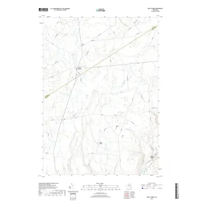
2019 Map of West Leyden
USGS Topo · Published 2019About this map
West Leyden and Ava anchor this landscape along the border of Lewis and Oneida Counties, where the upper reaches of the East Branch Mohawk River wind through rural Tug Hill country. The settlement pattern is defined by agricultural crossroads and scattered hamlets like Flint Town and Dunn Brook, reflecting a long history of dairy farming and timber interests. Notable for genealogists are the West Leyden Cem and Thorton Cem, which serve as quiet markers of the area's early families. In the southeast, the topography descends sharply toward the Lansing Kill gorge, a significant corridor where the remains of the Black River Canal once provided a vital link between the Erie Canal and the North Woods. Numerous tributaries, including Turtle Lot Brook and Harger Cr, underscore the well-watered nature of this highland region, while prominent elevations like Webster Hill provide clear vantage points over the creek-carved valleys.
Find a feature on this map
55 named features on this map. Tap any name to fly to it.
Don’t see what you’re looking for? This feature index may not catch every label — zoom into the map to look around manually.
Map Details
Editions of this 2019 West Leyden Map
This is the sole edition of this map. No revisions or reprints were ever made.
Other maps of this area

1904 · Boonville
USGS Topo · 1:62,500

1905 · Port Leyden
USGS Topo · 1:62,500

1905 · Taberg
USGS Topo · 1:62,500

1906 · Highmarket
USGS Topo · 1:62,500

1907 · Port Leyden
USGS Topo · 1:62,500

1940 · Port Leyden
USGS Topo · 1:62,500

1943 · Lee Center
USGS Topo · 1:31,680

1943 · High Market
USGS Topo · 1:24,000

1944 · Point Rock
USGS Topo · 1:31,680
1944 · Highmarket
USGS Topo · 1:31,680