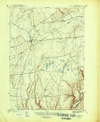
1946 Map of West Leyden
USGS Topo · Published 1946About this map
West Leyden serves as the primary hub in this mid-century survey, situated at the confluence of the East Branch Mohawk River and other upland tributaries. The landscape is defined by its rural school districts and family burial grounds, reflecting the dispersed nature of the dairy and timber communities along the Lewis Co Oneida Co line. Small hamlets like Redmond Corner and Flint Town punctuate the high ground, while evidence of early local industry persists at Swancott Mill. The map documents a dense network of country roads such as Esche Road and Dutch Hill Road, which linked remote farmsteads to educational centers like Evans Sch and Alger Sch. Significant topographic relief is noted at Webster Hill, overlooking the descent toward the Lansing Kill and Boonville Creek drainage systems.
Find a feature on this map
40 named features on this map. Tap any name to fly to it.
Don’t see what you’re looking for? This feature index may not catch every label — zoom into the map to look around manually.
Map Details
Editions of this 1946 West Leyden Map
This is the sole edition of this map. No revisions or reprints were ever made.
Other maps of this area

1904 · Boonville
USGS Topo · 1:62,500

1905 · Port Leyden
USGS Topo · 1:62,500

1905 · Taberg
USGS Topo · 1:62,500

1906 · Highmarket
USGS Topo · 1:62,500

1907 · Port Leyden
USGS Topo · 1:62,500

1940 · Port Leyden
USGS Topo · 1:62,500

1943 · Lee Center
USGS Topo · 1:31,680

1943 · High Market
USGS Topo · 1:24,000

1944 · Point Rock
USGS Topo · 1:31,680
1944 · Highmarket
USGS Topo · 1:31,680