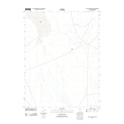
2012 Map of West of Beck Pass
USGS Topo · Published 2012About this map
Newark Valley dominates this 2012 topography, characterized by the expansive basin that defines the central geography of this portion of White Pine County. The landscape features the seasonally fluctuating Newark Lake, which occupies the northwestern portion of the quadrangle. In an arid environment where water sources are vital historical landmarks, Barrel Spring appears on the eastern slope of the valley, providing a specific point of interest for those studying early cattle ranching or transit routes through the Great Basin. Infrastructure is sparse, marked primarily by the diagonal path of Co RD-1, which cuts across the valley floor. The map illustrates the drainage patterns and alluvial fans common to the high desert, showing how water moves from the surrounding peaks toward the dry lake bed during periods of runoff.
Find a feature on this map
4 named features on this map. Tap any name to fly to it.
Don’t see what you’re looking for? This feature index may not catch every label — zoom into the map to look around manually.
Map Details
Editions of this 2012 West of Beck Pass Map
This is the sole edition of this map. No revisions or reprints were ever made.
Other maps of this area

1951 · Pancake Summit
USGS Topo · 1:62,500

1953 · Pinto Summit
USGS Topo · 1:62,500

1953 · Eureka
USGS Topo · 1:62,500

1956 · Ely
USGS Topo · 1:250,000

1957 · Buck Mountain
USGS Topo · 1:62,500

1959 · Ely
USGS Topo · 1:250,000

1963 · Ely
USGS Topo · 1:250,000

1979 · Mt. Hamilton
USGS Topo · 1:100,000

1985 · Newark Lake
USGS Topo · 1:100,000
1990 · Buck Mountain East
USGS Topo · 1:24,000