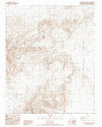
1987 Map of West of Black Hills
USGS Topo · Published 1987About this map
The Lava Mountains dominate this high-desert landscape in northeastern San Bernardino County, characterized by steep volcanic slopes and remote terrain. Established during a period of significant military land use in the Mojave Desert, a large portion of this territory is designated as the Naval Weapons Center. The map reveals a land managed for specific tactical and ecological needs, notably evidenced by the marking of a Guzzler, a specialized water catchment system designed to support local wildlife in an arid environment where natural springs are rare. Access throughout this rugged interior is limited primarily to a network of 4wd tracks, underscoring the area's isolation and its role as a restricted-use military zone during the late twentieth century.
Find a feature on this map
7 named features on this map. Tap any name to fly to it.
Don’t see what you’re looking for? This feature index may not catch every label — zoom into the map to look around manually.
Map Details
Editions of this 1987 West of Black Hills Map
This is the sole edition of this map. No revisions or reprints were ever made.
Other maps of this area

1903 · Randsburg
USGS Topo · 1:62,500

1911 · Randsburg
USGS Topo · 1:62,500

1912 · Randsburg
USGS Topo · 1:62,500

1915 · Searles Lake
USGS Topo · 1:250,000

1947 · Trona
USGS Topo · 1:250,000

1948 · Trona
USGS Topo · 1:250,000

1949 · Searles Lake
USGS Topo · 1:62,500

1950 · Searles Lake
USGS Topo · 1:62,500

1953 · Ridgecrest
USGS Topo · 1:62,500

1953 · Trona
USGS Topo · 1:250,000