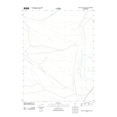
2012 Map of West of Coffin Mountain
USGS Topo · Published 2012About this map
Mojabelli Mine Rd cuts across the northern reaches of this high-desert landscape in Eureka County, providing a singular trace of industrial access in an otherwise water-defined region. The geography is dominated by a complex network of seasonal drainages and perennial flows, including the prominent Little Pole Creek and Big Pole Creek, which carve distinct paths through the terrain. In the eastern portion of the sheet, Pine Creek serves as a primary artery, receiving numerous smaller tributaries such as Hot Creek and the intermittent Dry Creek. The presence of Box Springs near the center of the quadrangle highlights the critical importance of localized water sources for both historical ranching and mining operations in this arid Nevada environment. The southern edge is defined by the winding course of Sheep Creek and the headwaters of Edwards Creek, illustrating the natural drainage patterns that have shaped land use and exploration in this remote mountain-shadowed area.
Find a feature on this map
9 named features on this map. Tap any name to fly to it.
Don’t see what you’re looking for? This feature index may not catch every label — zoom into the map to look around manually.
Map Details
Editions of this 2012 West of Coffin Mountain Map
This is the sole edition of this map. No revisions or reprints were ever made.
Other maps of this area

1937 · Mineral Hill
USGS Topo · 1:48,000

1943 · Mineral Hill
USGS Topo · 1:62,500

1952 · Pine Valley
USGS Topo · 1:62,500

1955 · Winnemucca
USGS Topo · 1:250,000

1957 · Frenchie Creek
USGS Topo · 1:62,500

1957 · Horse Creek Valley
USGS Topo · 1:62,500

1958 · Winnemucca
USGS Topo · 1:250,000

1962 · Winnemucca
USGS Topo · 1:250,000
1985 · Thatcher Spring
USGS Topo · 1:24,000
1985 · Coffin Mtn
USGS Topo · 1:24,000