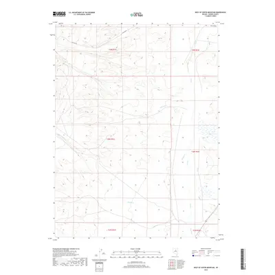
2018 Map of West of Coffin Mountain
USGS Topo · Published 2018About this map
Iron Mine Rd cuts through the northern high ground of this Eureka County landscape, signaling the region's long association with mineral extraction. The terrain is defined by the broad Pine Valley, where a network of ephemeral and perennial watercourses descend from the western uplands. Significant drainage systems including Little Pole Cr and Big Pole Cr flow toward the valley floor, eventually meeting Pine Cr as it tracks northward. This 2018 survey captures the hydrological complexity of the Great Basin, where features like Box Springs and small wetland clusters near Hot Cr and Pony Cr provide critical water points in an otherwise arid environment. The map provides a clear record of the Public Land Survey System grid, including Township 28 North, Range 51 East, illustrating how this expansive open range is partitioned for ranching and resource management.
Find a feature on this map
17 named features on this map. Tap any name to fly to it.
Don’t see what you’re looking for? This feature index may not catch every label — zoom into the map to look around manually.
Map Details
Editions of this 2018 West of Coffin Mountain Map
This is the sole edition of this map. No revisions or reprints were ever made.
Other maps of this area

1937 · Mineral Hill
USGS Topo · 1:48,000

1943 · Mineral Hill
USGS Topo · 1:62,500

1952 · Pine Valley
USGS Topo · 1:62,500

1955 · Winnemucca
USGS Topo · 1:250,000

1957 · Frenchie Creek
USGS Topo · 1:62,500

1957 · Horse Creek Valley
USGS Topo · 1:62,500

1958 · Winnemucca
USGS Topo · 1:250,000

1962 · Winnemucca
USGS Topo · 1:250,000
1985 · Thatcher Spring
USGS Topo · 1:24,000
1985 · Coffin Mtn
USGS Topo · 1:24,000