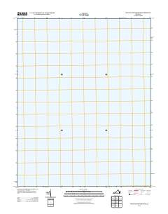
2013 Map of West of Franktown
USGS Topo · Published 2013About this map
Chesapeake Bay dominates this coastal survey, capturing a vast stretch of open water west of the Delmarva Peninsula in 2013. The map represents a maritime quadrangle located offshore from the Eastern Shore of Virginia, focusing entirely on the hydrography of the bay itself. This specific sheet illustrates the expanse of the bay before it narrows toward the northern reaches, serving as a clean record of the water's surface as defined by the U.S. Geological Survey for this nautical coordinate. Given the lack of terrestrial features, the document highlights the essential role of the Chesapeake Bay as a primary geographic landmark for Northampton County mariners and coastal researchers.
Find a feature on this map
1 named feature on this map. Tap any name to fly to it.
Don’t see what you’re looking for? This feature index may not catch every label — zoom into the map to look around manually.
Map Details
Editions of this 2013 West of Franktown Map
This is the sole edition of this map. No revisions or reprints were ever made.
Other maps of this area

1942 · Cheriton
USGS Topo · 1:24,000

1943 · Jamesville
USGS Topo · 1:31,680

1943 · Franktown
USGS Topo · 1:31,680

1943 · Richmond
USGS Topo · 1:250,000

1946 · Eastville
USGS Topo · 1:250,000

1948 · Cape Charles
USGS Topo · 1:24,000

1949 · Richmond
USGS Topo · 1:250,000
1955 · Cape Charles
USGS Topo · 1:24,000
1955 · Cheriton
USGS Topo · 1:24,000

1959 · Richmond
USGS Topo · 1:250,000