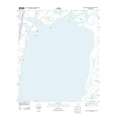
2013 Map of West of Greens Bayou
USGS Topo · Published 2013About this map
Sabine Lake dominates this coastal landscape where the Sabine River meets the Gulf marshlands along the Texas and Louisiana border. The western shore is defined by the heavy infrastructure of the Sabine Neches Canal and the northern tip of Pleasure Island, linked to the mainland by the Port Arthur-Orange Bridge. This area serves as a critical maritime corridor, evidenced by the Rainbow Marina and a network of named islands like Humble Island, Stewts Island, and Dooms Island. To the east, the landscape transitions into a complex delta of passes and bayous. Navigation through the marsh is marked by features such as Coon Bayou, Hickory Cove, and the East Pass, reflecting the intricate hydrography of the Sabine estuary. Several local roads, including Old Ferry Rd and Yacht Club Rd, provide access to the waterfront and industrial facilities along the canal.
Find a feature on this map
32 named features on this map. Tap any name to fly to it.
Don’t see what you’re looking for? This feature index may not catch every label — zoom into the map to look around manually.
Map Details
Editions of this 2013 West of Greens Bayou Map
This is the sole edition of this map. No revisions or reprints were ever made.
Other maps of this area

1926 · Terry
USGS Topo · 1:24,000

1932 · Orange
USGS Topo · 1:62,500

1932 · Port Arthur NE
USGS Topo · 1:31,680

1934 · Johnsons Bayou
USGS Topo · 1:24,000

1934 · Greens Bayou
USGS Topo · 1:24,000

1935 · Greens Bayou
USGS Topo · 1:31,680

1935 · Johnsons Bayou
USGS Topo · 1:31,680

1943 · West of Johnson Bayou
USGS Topo · 1:24,000

1943 · West of Greens Bayou
USGS Topo · 1:24,000

1943 · Orangefield
USGS Topo · 1:24,000