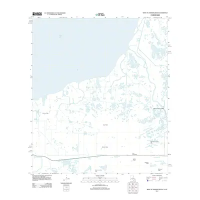
2012 Map of West of Johnson Bayou
USGS Topo · Published 2012About this map
The coastal marshlands along the Louisiana-Texas border define this landscape, where the expansive waters of Sabine Lake dominate the northwestern quadrant. This low-lying terrain is characterized by a series of narrow, elevated landforms including Garrison Ridge, Buck Ridge, and Blue Buck Ridge, which provided the only stable ground for historical development and access. The map reveals an intricate network of natural and engineered waterways, such as Madame Johnson Bayou and Grays Ditch, essential for navigating the wet prairie. Industrial activity is concentrated in the energy sector, marked by the Northwest Johnson Bayou Gas Field and West Johnson Bayou Gas Field. Near the eastern boundary, Johnson Bayou Landing serves as a focal point for local transport and commerce. The presence of Salt Work Ridge hints at earlier geological and economic uses of the land, while Starks S Canal illustrates the ongoing human effort to manage drainage and navigation in this complex estuarine environment.
Find a feature on this map
18 named features on this map. Tap any name to fly to it.
Don’t see what you’re looking for? This feature index may not catch every label — zoom into the map to look around manually.
Map Details
Editions of this 2012 West of Johnson Bayou Map
This is the sole edition of this map. No revisions or reprints were ever made.
Other maps of this area

1932 · Sabine Pass NE
USGS Topo · 1:31,680

1932 · Port Arthur NE
USGS Topo · 1:31,680

1934 · Johnsons Bayou
USGS Topo · 1:24,000

1934 · Greens Bayou
USGS Topo · 1:24,000

1935 · Greens Bayou
USGS Topo · 1:31,680

1935 · Johnsons Bayou
USGS Topo · 1:31,680

1943 · West of Johnson Bayou
USGS Topo · 1:24,000

1943 · West of Greens Bayou
USGS Topo · 1:24,000

1943 · Port Arthur North
USGS Topo · 1:24,000

1943 · Port Arthur South
USGS Topo · 1:24,000