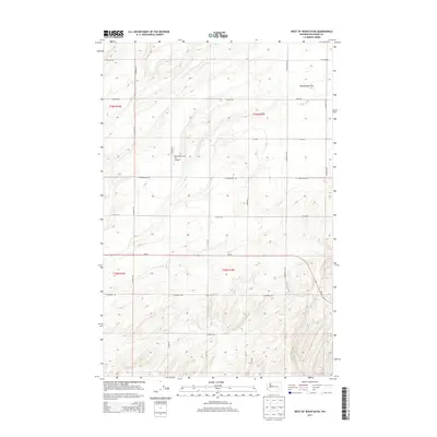
2013 Map of West of Washtucna
USGS Topo · Published 2013About this map
Rattlesnake Flat dominates the northeast corner of this agricultural landscape in Adams County, where the high plateau is etched by a network of section-line roads and seasonal drainage patterns. The area is characterized by large-scale farming operations, anchored by the Baumann Farm Inc Airport situated near S Bauer Rd. This private airstrip underscores the reliance on aerial coordination for rural land management in the Palouse region. The map captures a vital transportation corridor via Wa-26, which bisects the southern half of the quadrangle, connecting these high-plains holdings. Family-named roads such as S Dewald Rd, S Marcellus Rd, and S Bauman Rd define the property boundaries and transport routes of the mid-20th century ranching and farming legacy that persists into the 2010s.
Find a feature on this map
23 named features on this map. Tap any name to fly to it.
Don’t see what you’re looking for? This feature index may not catch every label — zoom into the map to look around manually.
Map Details
Editions of this 2013 West of Washtucna Map
This is the sole edition of this map. No revisions or reprints were ever made.
Other maps of this area

1916 · Connell
USGS Topo · 1:125,000

1918 · Connell
USGS Topo · 1:125,000

1923 · Washtucna
USGS Topo · 1:62,500

1925 · Washtucna
USGS Topo · 1:62,500

1948 · Ayer
USGS Topo · 1:62,500

1950 · Haas
USGS Topo · 1:62,500

1953 · Walla Walla
USGS Topo · 1:250,000

1958 · Walla Walla
USGS Topo · 1:250,000

1970 · Lind SE
USGS Topo · 1:24,000
1970 · Lind
USGS Topo · 1:24,000