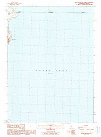
1990 Map of West of Willow Ranch
USGS Topo · Published 1990About this map
Goose Lake dominates this 1990 survey, showing the expansive alkaline waters along the Oregon and California border at an elevation of 4701 feet. The map focuses on the western shoreline where the Modoc National Forest meets the water's edge. A notable concentration of activity appears in the northwest corner, where Point Ranch and Log Landing mark the intersection of ranching and timber interests at the state line between Lake and Modoc counties. The lack of significant road infrastructure or dense settlement emphasizes the transitional nature of this shoreline environment, where the land and lake meet in a relatively undisturbed high-desert landscape.
Find a feature on this map
10 named features on this map. Tap any name to fly to it.
Don’t see what you’re looking for? This feature index may not catch every label — zoom into the map to look around manually.
Map Details
Editions of this 1990 West of Willow Ranch Map
This is the sole edition of this map. No revisions or reprints were ever made.
Other maps of this area

1886 · Alturas
USGS Topo · 1:250,000

1892 · Alturas
USGS Topo · 1:250,000

1954 · Alturas
USGS Topo · 1:250,000

1955 · Klamath Falls
USGS Topo · 1:250,000

1958 · Alturas
USGS Topo · 1:250,000

1958 · Klamath Falls
USGS Topo · 1:250,000

1962 · Alturas
USGS Topo · 1:250,000

1962 · Willow Ranch
USGS Topo · 1:62,500

1962 · South Mountain
USGS Topo · 1:62,500

1964 · Lakeview SW
USGS Topo · 1:24,000