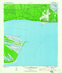
1943 Map of West Pass
USGS Topo · Published 1960About this map
The St Vincent Island landscape dominates the southern portion of this mid-century survey, revealing a complex network of coastal wetlands and ridges including Big Bayou, Mallard Slough, and Beck Slough. Across the waters of St Vincent Sound, the mainland shoreline is marked by Green Point and the industrial infrastructure of the City of Apalachicola. Significant aviation history is visible at the Apalachicola Airport, while the Apalachicola Northern railroad tracks cut through the pine flatwoods toward the small settlement at Tilton. The eastern edge highlights the maritime activity at the mouth of the Apalachicola River, showing Turtle Harbor and Scipio Creek before they empty into the wide Apalachicola Bay. This coastal survey provides a detailed record of the region's topography before significant modern development altered the shoreline and marsh drainage patterns.
Find a feature on this map
26 named features on this map. Tap any name to fly to it.
Don’t see what you’re looking for? This feature index may not catch every label — zoom into the map to look around manually.
Map Details
Editions of this 1943 West Pass Map
5 editions found
Other maps of this area

1943 · West Pass
USGS Topo · 1:31,680

1943 · Apalachicola
USGS Topo · 1:31,680

1943 · Indian Pass
USGS Topo · 1:24,000

1943 · Jackson River
USGS Topo · 1:24,000

1944 · Apalachicola
USGS Topo · 1:24,000

1945 · Cape St. George
USGS Topo · 1:31,680

1945 · Lake Wimico
USGS Topo · 1:31,680

1945 · Beverly
USGS Topo · 1:31,680

1945 · Jackson River
USGS Topo · 1:31,680

1945 · Indian Pass
USGS Topo · 1:31,680