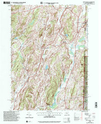
1995 Map of West Pawlet
USGS Topo · Published 2000About this map
The New York-Vermont border splits this landscape, where the rugged terrain of Slate Hill and Round Mountain overlooks a network of small agricultural and industrial hamlets. West Pawlet sits at the edge of the Indian River, while to the west, settlements like Slateville and Chamberlain Mills hint at the local economies tied to the land and water. The map is particularly dense with genealogical markers, including numerous family-named cemeteries such as Tanner Cem, Taylor Hill Cem, and Burch Cem that dot the hillsides.
Find a feature on this map
39 named features on this map. Tap any name to fly to it.
Don’t see what you’re looking for? This feature index may not catch every label — zoom into the map to look around manually.
Map Details
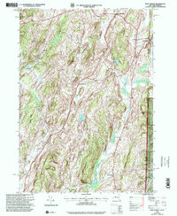
Editions of this 1995 West Pawlet Map
2 editions found
Other maps of this area

1893 · Fort Ann
USGS Topo · 1:62,500

1894 · Pawlet
USGS Topo · 1:62,500

1894 · Equinox
USGS Topo · 1:62,500

1895 · Cambridge
USGS Topo · 1:62,500

1895 · Fort Ann
USGS Topo · 1:62,500

1896 · Equinox
USGS Topo · 1:62,500

1897 · Pawlet
USGS Topo · 1:62,500

1898 · Cambridge
USGS Topo · 1:62,500

1898 · Fort Ann
USGS Topo · 1:62,500

1900 · Equinox
USGS Topo · 1:62,500