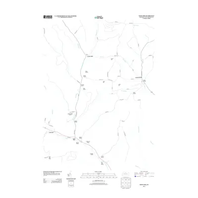
2013 Map of West Pike
USGS Topo · Published 2013About this map
West Pike and Sunderlinville serve as the primary nodes of settlement in this part of Hector Township, where the headwaters of Pine Cr and Genesee Forks carve deep into the plateau. The landscape is defined by a dense network of named hollows, such as Crandall Hollow, Judson Hollow, and Hardscrabble Hollow, which reveal the historical patterns of local land use and family homesteads. Higher elevations like Stiles Hill and Parker Hill overlook the narrow valley corridors where sr1004 and Old Route 6 provide the main thoroughfares. Rock Run Vista offers a look at the topographic character of the region, where numerous small brooks like Barn Brook and Thunder Run feed the primary drainages. The distribution of small settlements like Loucks Mills and Telescope alongside these watercourses suggests an era when local industry and agriculture were tied closely to the available water power and valley floor access.
Find a feature on this map
72 named features on this map. Tap any name to fly to it.
Don’t see what you’re looking for? This feature index may not catch every label — zoom into the map to look around manually.
Map Details
Editions of this 2013 West Pike Map
This is the sole edition of this map. No revisions or reprints were ever made.
Other maps of this area

1899 · Gaines
USGS Topo · 1:62,500

1900 · Gaines
USGS Topo · 1:62,500

1932 · Genesee
USGS Topo · 1:62,500

1937 · Genesee
USGS Topo · 1:62,500

1947 · Conrad
USGS Topo · 1:62,500

1947 · Galeton
USGS Topo · 1:62,500

1947 · Cherry Springs
USGS Topo · 1:24,000

1947 · Galeton
USGS Topo · 1:24,000

1947 · Marshlands
USGS Topo · 1:24,000
1949 · Galeton
USGS Topo · 1:24,000
Featured Places
- Hector Township, PA
- Loucks Mills, Hector Township
- Sunderlinville, Hector Township
- Pike Township, PA
- Ulysses Township, PA