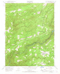
1948 Map of West Point
USGS Topo · Published 1968About this map
The Amador and Calaveras county line divides this Mother Lode landscape, where the confluence of the North Fork Mokelumne River and the Middle Fork Mokelumne River dictates the rugged topography. Post-war industrial infrastructure is evident at the West Point Power House and the Tiger Creek Reservoir, which harness the high-gradient flows of the river system. These modern installations sit alongside a deep history of extraction, evidenced by various hard-rock operations such as the Mackay Mine, Belden Mine, and Yellow Aster Mine.
Find a feature on this map
33 named features on this map. Tap any name to fly to it.
Don’t see what you’re looking for? This feature index may not catch every label — zoom into the map to look around manually.
Map Details
Editions of this 1948 West Point Map
4 editions found
Other maps of this area

1889 · Jackson
USGS Topo · 1:125,000

1889 · Pyramid Peak
USGS Topo · 1:125,000

1891 · Big Trees
USGS Topo · 1:125,000

1891 · Placerville
USGS Topo · 1:125,000

1891 · Pyramid Peak
USGS Topo · 1:125,000

1892 · Jackson
USGS Topo · 1:125,000

1892 · Placerville
USGS Topo · 1:125,000

1893 · Placerville
USGS Topo · 1:125,000

1894 · Big Trees
USGS Topo · 1:125,000

1895 · Pyramid Peak
USGS Topo · 1:125,000