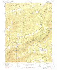
1948 Map of West Point
USGS Topo · Published 1976About this map
West Point and its neighboring settlements anchor this 1948 survey of the Mother Lode's rugged foothills. The landscape is defined by the convergence of the North Fork Mokelumne River and the Middle Fork Mokelumne River, where the Upper Standard Canal and Lower Standard Canal systems snake along steep canyon walls to supply the West Point Power House. The map documents a transition from early extraction to a more settled rural economy, with active and dormant mining operations like the Black Prince Mine and Yellow Aster Mine scattered among family holdings like the Goodman Ranch.
Find a feature on this map
37 named features on this map. Tap any name to fly to it.
Don’t see what you’re looking for? This feature index may not catch every label — zoom into the map to look around manually.
Map Details
Editions of this 1948 West Point Map
4 editions found
Other maps of this area

1889 · Jackson
USGS Topo · 1:125,000

1889 · Pyramid Peak
USGS Topo · 1:125,000

1891 · Big Trees
USGS Topo · 1:125,000

1891 · Placerville
USGS Topo · 1:125,000

1891 · Pyramid Peak
USGS Topo · 1:125,000

1892 · Jackson
USGS Topo · 1:125,000

1892 · Placerville
USGS Topo · 1:125,000

1893 · Placerville
USGS Topo · 1:125,000

1894 · Big Trees
USGS Topo · 1:125,000

1895 · Pyramid Peak
USGS Topo · 1:125,000