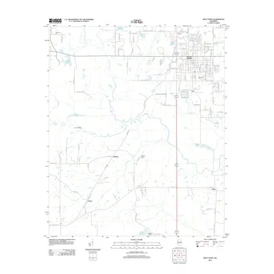
2012 Map of West Point
USGS Topo · Published 2012About this map
The city of West Point serves as the focal point for this survey, revealing a landscape defined by its riparian networks and aviation infrastructure. The convergence of Chuquatonchee Cr, Line Cr, and Town Cr into Tibbee Cr shapes the southern and western reaches of the quadrangle, influencing the locations of rural settlements like Lyons Bluff and Tibbee. Historically significant sites, such as the Mayhew Mission Cem and Greenwood Cem, provide vital touchpoints for genealogical research in this portion of Clay County. The presence of both McCharen Field Airport and Oktibbeha Airport underscores the importance of regional transport, while the grid of West Point shows the continued vitality of its residential and commercial core around the Post Office and Lake Wooten.
Find a feature on this map
125 named features on this map. Tap any name to fly to it.
Don’t see what you’re looking for? This feature index may not catch every label — zoom into the map to look around manually.
Map Details
Editions of this 2012 West Point Map
This is the sole edition of this map. No revisions or reprints were ever made.
Other maps of this area

1953 · West Point
USGS Topo · 1:250,000

1958 · West Point
USGS Topo · 1:250,000

1959 · Artesia
USGS Topo · 1:62,500

1959 · West Point
USGS Topo · 1:62,500

1959 · Pheba
USGS Topo · 1:62,500

1963 · West Point
USGS Topo · 1:250,000

1965 · Starkville
USGS Topo · 1:24,000

1982 · West Point
USGS Topo · 1:100,000

1984 · West Point
USGS Topo · 1:250,000
1987 · Cedar Bluff
USGS Topo · 1:24,000