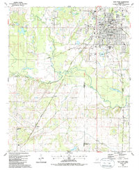
1987 Map of West Point
USGS Topo · Published 1987About this map
The city of West Point serves as the focal point of this late-1980s landscape, where urban infrastructure meets the complex river systems of the Black Prairie. The city’s growth is evidenced by a dense network of educational facilities, ranging from Oak Hill Academy and West Point High Sch to several junior high schools. Beyond the city limits, the terrain is defined by the winding paths of Chuquatonchee Creek, Tibbee Creek, and Line Creek, which historically dictated the boundaries and agricultural potential of this region.
Find a feature on this map
58 named features on this map. Tap any name to fly to it.
Don’t see what you’re looking for? This feature index may not catch every label — zoom into the map to look around manually.
Map Details
Editions of this 1987 West Point Map
This is the sole edition of this map. No revisions or reprints were ever made.
Other maps of this area

1953 · West Point
USGS Topo · 1:250,000

1958 · West Point
USGS Topo · 1:250,000

1959 · Artesia
USGS Topo · 1:62,500

1959 · West Point
USGS Topo · 1:62,500

1959 · Pheba
USGS Topo · 1:62,500

1963 · West Point
USGS Topo · 1:250,000

1965 · Starkville
USGS Topo · 1:24,000

1982 · West Point
USGS Topo · 1:100,000

1984 · West Point
USGS Topo · 1:250,000
1987 · Cedar Bluff
USGS Topo · 1:24,000