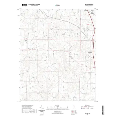
2020 Map of West Point
USGS Topo · Published 2020About this map
West Point and the surrounding rural communities of Bethel and Spring Hill sit atop a dissected plateau north of the city of Cullman. The landscape is defined by the Brindley Valley Mountain Divide and prominent elevations such as Hog Mtn and Haynes Mtn, which separate the many creek branches flowing through the territory. This 2020 survey reveals a dense network of county roads connecting numerous community anchors, particularly small burial grounds and family-named cemeteries. Notable sites including Pilgrims Rest Cem, Spitznagl Cem, and Bethsadia Cem are scattered across the terrain, reflecting the long-standing settlement patterns of Cullman County. From the industrial outskirts of Good Hope to the quiet hollows of Sweetgum Hollow, the map documents the transition between residential growth and the traditional agricultural topography of north-central Alabama.
Find a feature on this map
159 named features on this map. Tap any name to fly to it.
Don’t see what you’re looking for? This feature index may not catch every label — zoom into the map to look around manually.
Map Details
Editions of this 2020 West Point Map
This is the sole edition of this map. No revisions or reprints were ever made.
Other maps of this area

1888 · Cullman
USGS Topo · 1:125,000

1892 · Cullman
USGS Topo · 1:125,000

1927 · Falkville
USGS Topo · 1:24,000

1935 · Danville
USGS Topo · 1:48,000

1936 · Mc Kendry
USGS Topo · 1:24,000

1936 · Eva
USGS Topo · 1:24,000

1938 · Danville
USGS Topo · 1:62,500

1949 · Falkville
USGS Topo · 1:24,000
1949 · Eva
USGS Topo · 1:24,000
1951 · Eva
USGS Topo · 1:24,000