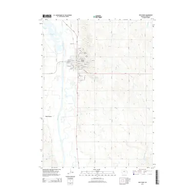
2014 Map of West Point
USGS Topo · Published 2014About this map
West Point serves as the primary hub of this eastern Nebraska landscape, situated along the eastern banks of the Elkhorn River. The town's grid is well-established, featuring a mix of residential streets like E Walnut St and S Niphon St, alongside essential community sites such as Mt Hope Cem and Saint Josephs Cem. To the south, Saint Michael Cem sits near the intersection of Us-275 and Ne-32, marking the transition to the surrounding agricultural plains. The terrain is defined by a series of waterways, including Plum Creek, Wortmans Cr, and the oxbows of Horseshoe Lake. The rural landscape is divided by a systematic network of section roads, such as D Rd and C Rd, which connect the scattered settlement of Saint Charles to the regional center of West Point, reflecting the late 20th-century development of Cuming County.
Find a feature on this map
58 named features on this map. Tap any name to fly to it.
Don’t see what you’re looking for? This feature index may not catch every label — zoom into the map to look around manually.
Map Details
Editions of this 2014 West Point Map
This is the sole edition of this map. No revisions or reprints were ever made.
Other maps of this area

1955 · Fremont
USGS Topo · 1:250,000

1957 · Fremont
USGS Topo · 1:250,000

1958 · Fremont
USGS Topo · 1:250,000

1966 · West Point NW
USGS Topo · 1:24,000

1966 · West Point SE
USGS Topo · 1:24,000

1966 · Uehling
USGS Topo · 1:24,000

1966 · Monterey
USGS Topo · 1:24,000
1966 · Beemer
USGS Topo · 1:24,000

1966 · Snyder
USGS Topo · 1:24,000

1966 · West Point NE
USGS Topo · 1:24,000