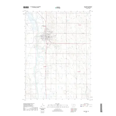
2017 Map of West Point
USGS Topo · Published 2017About this map
West Point serves as the central hub of this Cuming County landscape, situated along the eastern banks of the Elkhorn River. The town's grid is well-established, featuring its central Po and several local landmarks including Mount Hope Cem and Saint Josephs Cem to the north. To the south, Saint Michael Cem sits just off the road grid. The surrounding terrain is defined by a dense network of waterways and drainage systems, including the oxbow formations at Horseshoe Lake and the winding paths of Plum Creek, Fisher Cr, and Wortmans Cr. The rural character of the area is further evidenced by Bracht Reservoir and the extensive system of section-line roads, such as 17th Rd and Washington St, which connect the agrarian countryside to the municipal center. This contemporary survey captures the town's position as a river-valley settlement surrounded by the meticulously managed hydrology of the Nebraska plains.
Find a feature on this map
70 named features on this map. Tap any name to fly to it.
Don’t see what you’re looking for? This feature index may not catch every label — zoom into the map to look around manually.
Map Details
Editions of this 2017 West Point Map
This is the sole edition of this map. No revisions or reprints were ever made.
Other maps of this area

1955 · Fremont
USGS Topo · 1:250,000

1957 · Fremont
USGS Topo · 1:250,000

1958 · Fremont
USGS Topo · 1:250,000

1966 · West Point NW
USGS Topo · 1:24,000

1966 · West Point SE
USGS Topo · 1:24,000

1966 · Uehling
USGS Topo · 1:24,000

1966 · Monterey
USGS Topo · 1:24,000
1966 · Beemer
USGS Topo · 1:24,000

1966 · Snyder
USGS Topo · 1:24,000

1966 · West Point NE
USGS Topo · 1:24,000