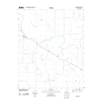
2011 Map of West Point
USGS Topo · Published 2011About this map
The Little Red River winds through this White County landscape, defining the character of West Point and its surrounding floodplains. This 2011 survey shows a region deeply tied to its water systems, where numerous sloughs and lakes like Milliken Lake and Barbers Lake occupy the lowlands between the river and Hogpen Ridge. The settlement pattern follows established corridors, with West Point situated near the riverbanks while Andrews, Pryor, and Enright are positioned along the primary road and former rail alignments. Local history is anchored by Riverside Cemetery near the river, while the names of smaller landmarks like Bailey Lake Hill and Lost Hill hint at the subtle topography of the Arkansas delta region. The intricate network of drainage, including Cypress Slough and Cutoff Slough, illustrates the ongoing management of this fertile, water-rich territory.
Find a feature on this map
44 named features on this map. Tap any name to fly to it.
Don’t see what you’re looking for? This feature index may not catch every label — zoom into the map to look around manually.
Map Details
Editions of this 2011 West Point Map
This is the sole edition of this map. No revisions or reprints were ever made.
Other maps of this area

1932 · Kensett
USGS Topo · 1:62,500

1935 · Kensett
USGS Topo · 1:62,500

1935 · Augusta
USGS Topo · 1:62,500

1935 · Gregory
USGS Topo · 1:62,500

1935 · Bald Knob
USGS Topo · 1:62,500

1953 · Memphis
USGS Topo · 1:250,000

1956 · Memphis
USGS Topo · 1:250,000

1957 · Augusta
USGS Topo · 1:62,500

1957 · Gregory
USGS Topo · 1:62,500
1964 · Walker
USGS Topo · 1:24,000