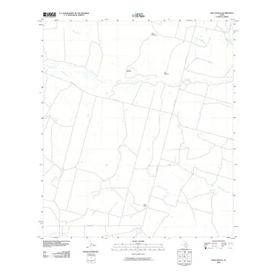
2010 Map of West Ranch
USGS Topo · Published 2010About this map
West Ranch serves as the central landmark in this portion of Frio County, where a network of South Texas ranch roads and waterways define the rural landscape. The winding course of the Leona River bisects the quadrangle, joined by tributaries such as Liveoak Creek and Todos Santos Creek. This environment is characterized by large-scale agricultural operations, evidenced by the presence of named infrastructure like the White Windmill, Roberts Windmill, and Red Windmill scattered across the drainage basins.
Find a feature on this map
15 named features on this map. Tap any name to fly to it.
Don’t see what you’re looking for? This feature index may not catch every label — zoom into the map to look around manually.
Map Details
Editions of this 2010 West Ranch Map
This is the sole edition of this map. No revisions or reprints were ever made.
Other maps of this area

1939 · Big Wells
USGS Topo · 1:62,500

1942 · Divot
USGS Topo · 1:62,500

1953 · Crystal City
USGS Topo · 1:250,000

1955 · Crystal City
USGS Topo · 1:250,000

1956 · Woodward
USGS Topo · 1:62,500

1956 · Divot
USGS Topo · 1:62,500

1957 · Batesville
USGS Topo · 1:62,500

1961 · Crystal City
USGS Topo · 1:250,000

1968 · Crystal City
USGS Topo · 1:250,000
1972 · Batesville
USGS Topo · 1:24,000