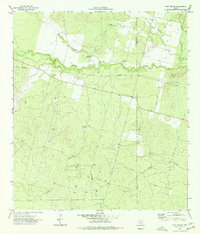
1974 Map of West Ranch
USGS Topo · Published 1977About this map
The Leona River meanders across this South Texas landscape, defining the boundary between Zavala and Frio counties during the mid-1970s. This territory is characterized by its agricultural and energy development, centered around the West Ranch settlement. The reliance on groundwater in this arid brush country is evident through several named landmarks, including White Windmill, Roberts Windmill, and Red Windmill, which served as critical water points for livestock and inhabitants.
Find a feature on this map
15 named features on this map. Tap any name to fly to it.
Don’t see what you’re looking for? This feature index may not catch every label — zoom into the map to look around manually.
Map Details
Editions of this 1974 West Ranch Map
This is the sole edition of this map. No revisions or reprints were ever made.
Other maps of this area

1939 · Big Wells
USGS Topo · 1:62,500

1942 · Divot
USGS Topo · 1:62,500

1953 · Crystal City
USGS Topo · 1:250,000

1955 · Crystal City
USGS Topo · 1:250,000

1956 · Woodward
USGS Topo · 1:62,500

1956 · Divot
USGS Topo · 1:62,500

1957 · Batesville
USGS Topo · 1:62,500

1961 · Crystal City
USGS Topo · 1:250,000

1968 · Crystal City
USGS Topo · 1:250,000
1972 · Batesville
USGS Topo · 1:24,000