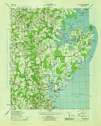
1944 Map of West River
USGS Topo · Published 1944About this map
The coastal landscapes of Anne Arundel County are defined by deep inlets and thriving maritime communities in this mid-century survey. Along the shores of the West River and Rhode River, established settlements like Galesville and Shadyside serve as focal points for local commerce and navigation, supported by infrastructure such as the Hartge Boat Yard and various aids like the West River Inner Lt 4. The map reveals a dense network of social foundations, including the Southern HS, Lothian Sch, and numerous congregations such as St Pauls Ch and Owensville Church.
Find a feature on this map
89 named features on this map. Tap any name to fly to it.
Don’t see what you’re looking for? This feature index may not catch every label — zoom into the map to look around manually.
Map Details
Editions of this 1944 West River Map
This is the sole edition of this map. No revisions or reprints were ever made.
Other maps of this area

1892 · Prince Frederick
USGS Topo · 1:62,500

1892 · Owensville
USGS Topo · 1:62,500

1892 · Annapolis
USGS Topo · 1:62,500

1893 · Sharps Island
USGS Topo · 1:62,500

1895 · Prince Frederick
USGS Topo · 1:62,500

1895 · Owensville
USGS Topo · 1:62,500

1898 · Choptank
USGS Topo · 1:125,000

1899 · Patuxent
USGS Topo · 1:125,000

1901 · Prince Frederick
USGS Topo · 1:62,500

1904 · Annapolis
USGS Topo · 1:62,500