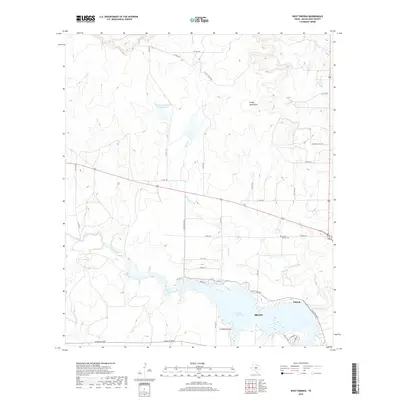
2019 Map of West Sweden
USGS Topo · Published 2019About this map
Brady Reservoir dominates the southern landscape of this McCulloch County region, where the waters of Brady Creek and Bowie Creek converge. The terrain is defined by the elevation of the Brady Mountains to the north, creating a distinct topographical boundary for the ranching and agricultural lands below. Evidence of early community life is preserved at the Carroll Colony Cem, located north of the settlement area of Niblock. The map illustrates a transition from the structured street grid of nearby Brady, seen at Lohn St and Melvin St, into an expansive network of rural county roads and private ranch gates. This layout reflects the local reliance on water management and land access, as seen in the presence of Reservoir Number Fortythree A and the winding course of Crooked Hollow.
Find a feature on this map
37 named features on this map. Tap any name to fly to it.
Don’t see what you’re looking for? This feature index may not catch every label — zoom into the map to look around manually.
Map Details
Editions of this 2019 West Sweden Map
This is the sole edition of this map. No revisions or reprints were ever made.
Other maps of this area

1892 · Eden
USGS Topo · 1:125,000

1894 · Brady
USGS Topo · 1:125,000

1896 · Eden
USGS Topo · 1:125,000

1928 · Waldrip
USGS Topo · 1:62,500

1931 · Stacy
USGS Topo · 1:62,500

1954 · Brownwood
USGS Topo · 1:250,000

1960 · West Sweden
USGS Topo · 1:24,000

1960 · Melvin
USGS Topo · 1:24,000

1960 · Brady North
USGS Topo · 1:24,000

1963 · Brady SW
USGS Topo · 1:24,000