
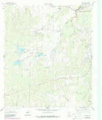
1963 Map of Brady SW
USGS Topo · Published 1964About this map
Brady Reservoir sits at the northern edge of this McCulloch County landscape, recorded during a period of active water management and infrastructure development in the early 1960s. The terrain is defined by an intricate network of drainage systems, including Crooked Creek, Bear Creek, and Post Oak Creek, which carve through the Texas brush country. Several smaller impoundments, specifically Reservoir No 6, Reservoir No 4, and Reservoir No 5, are documented with their respective spillway elevations, such as Spillway Elev 1915. These features, along with scattered Quarry sites, indicate a landscape modified for ranching and resource extraction. Farther south, the watershed transitions toward Camp Creek and Rumsey Creek, offering a detailed view of the rural topography before later decades of further development or land-use changes altered these drainages.
Find a feature on this map
16 named features on this map. Tap any name to fly to it.
Don’t see what you’re looking for? This feature index may not catch every label — zoom into the map to look around manually.
Map Details
Editions of this 1963 Brady SW Map
2 editions found
Other maps of this area

1887 · Mason
USGS Topo · 1:125,000

1892 · Eden
USGS Topo · 1:125,000

1894 · Brady
USGS Topo · 1:125,000

1894 · Mason
USGS Topo · 1:125,000

1896 · Eden
USGS Topo · 1:125,000

1954 · Brownwood
USGS Topo · 1:250,000

1954 · Llano
USGS Topo · 1:250,000

1955 · Llano
USGS Topo · 1:250,000

1956 · Llano
USGS Topo · 1:250,000

1960 · West Sweden
USGS Topo · 1:24,000