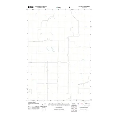
2011 Map of West Twin Butte
USGS Topo · Published 2011About this map
Plain View Cemetery sits at the intersection of County Rd 11 and 26th St SW, serving as a central landmark in this portion of Golden Valley County. The landscape is defined by the drainage basins of Elk Creek and its tributary, East Branch Elk Creek, which carve a network of coulees across the northern and central sections. To the southeast, the terrain rises toward the prominent West Twin Butte, situated near the headwaters of Wannagan Creek and Winter Creek. The road network follows a strict section-line grid typical of the Great Plains, with routes like Westerheim Rd and 159th Ave SW providing access to isolated farmsteads and agricultural tracts. This 2011 survey reflects the enduring rural character of western North Dakota, where transport relies on a mix of established county roads and local gravel routes like Elk Creek Rd.
Find a feature on this map
21 named features on this map. Tap any name to fly to it.
Don’t see what you’re looking for? This feature index may not catch every label — zoom into the map to look around manually.
Map Details
Editions of this 2011 West Twin Butte Map
This is the sole edition of this map. No revisions or reprints were ever made.
Other maps of this area

1953 · Dickinson
USGS Topo · 1:250,000

1953 · Watford City
USGS Topo · 1:250,000

1957 · Dickinson
USGS Topo · 1:250,000

1957 · Watford City
USGS Topo · 1:250,000

1967 · Watford City
USGS Topo · 1:250,000

1974 · Hootowl Creek West
USGS Topo · 1:24,000

1974 · West Twin Butte
USGS Topo · 1:24,000

1974 · Roosevelt Creek West
USGS Topo · 1:24,000
1974 · Hootowl Creek SW
USGS Topo · 1:24,000

1974 · Wannagan Creek West
USGS Topo · 1:24,000