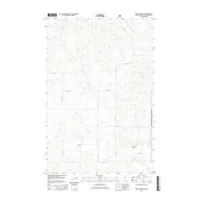
2014 Map of West Twin Butte
USGS Topo · Published 2014About this map
Plain View Cem sits as a solitary landmark in this 2014 survey of Golden Valley County, where the high plains terrain is defined by its drainage networks rather than dense settlement. The landscape is marked by the branching headwaters of Elk Cr, including the winding E Branch Elk Cr, which carve shallow paths through the western Dakotas. Along the eastern edge, the Little Missouri National Grassland encompasses a portion of the map, signifying the transition into protected public lands. The namesake West Twin Butte rises in the southeastern quadrant, providing a distinct topographic reference point near the intersection of Twin Butte Rd and the section line roads like 26th St SW. The area's character is strictly agricultural and pastoral, reflected in the orderly grid of section roads such as Westerheim Rd and Elk Creek Rd that navigate the seasonal flows of Wannagan Cr and Winter Cr.
Find a feature on this map
14 named features on this map. Tap any name to fly to it.
Don’t see what you’re looking for? This feature index may not catch every label — zoom into the map to look around manually.
Map Details
Editions of this 2014 West Twin Butte Map
This is the sole edition of this map. No revisions or reprints were ever made.
Other maps of this area

1953 · Dickinson
USGS Topo · 1:250,000

1953 · Watford City
USGS Topo · 1:250,000

1957 · Dickinson
USGS Topo · 1:250,000

1957 · Watford City
USGS Topo · 1:250,000

1967 · Watford City
USGS Topo · 1:250,000

1974 · Hootowl Creek West
USGS Topo · 1:24,000

1974 · West Twin Butte
USGS Topo · 1:24,000

1974 · Roosevelt Creek West
USGS Topo · 1:24,000
1974 · Hootowl Creek SW
USGS Topo · 1:24,000

1974 · Wannagan Creek West
USGS Topo · 1:24,000