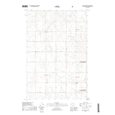
2020 Map of West Twin Butte
USGS Topo · Published 2020About this map
West Twin Butte rises above the complex drainage networks of Golden Valley County, where the high plains of western North Dakota transition into the protected reaches of the Little Missouri National Grassland. This 2020 landscape is defined by the headwaters and branches of Elk Cr, E Br Elk Cr, and Wannagan Cr, which carve through the terrain in a fractal pattern of coulees and draws. The map documents a sparsely populated ranching region organized by a strict section line road grid, including Twin Butte Rd and Co Rd 11. A primary site for local history is the Plain View Cem, located in the southern half of the quadrangle near 161st Ave SW, providing a specific point of reference for genealogists tracing family roots in this corner of the state.
Find a feature on this map
24 named features on this map. Tap any name to fly to it.
Don’t see what you’re looking for? This feature index may not catch every label — zoom into the map to look around manually.
Map Details
Editions of this 2020 West Twin Butte Map
This is the sole edition of this map. No revisions or reprints were ever made.
Other maps of this area

1953 · Dickinson
USGS Topo · 1:250,000

1953 · Watford City
USGS Topo · 1:250,000

1957 · Dickinson
USGS Topo · 1:250,000

1957 · Watford City
USGS Topo · 1:250,000

1967 · Watford City
USGS Topo · 1:250,000

1974 · Hootowl Creek West
USGS Topo · 1:24,000

1974 · West Twin Butte
USGS Topo · 1:24,000

1974 · Roosevelt Creek West
USGS Topo · 1:24,000
1974 · Hootowl Creek SW
USGS Topo · 1:24,000

1974 · Wannagan Creek West
USGS Topo · 1:24,000