1976 Map of West Union
USGS Topo · Published 1978About this map
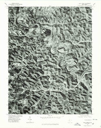
West Union serves as the focal point for this orthophotoquad, which emphasizes the tight valley floor and surrounding high ridges characteristic of this portion of Doddridge County. The winding course of Middle Island Creek dominates the landscape, its serpentine meanders cutting deep into the terrain and dictating the placement of early infrastructure and settlement. To the west, the community of Central Station sits at a strategic point within the rugged topography. This 1976 aerial perspective, produced in cooperation with the Soil Conservation Service, reveals the intricate relationship between land use and the natural drainage patterns of the region. The photo-based imagery provides a clear view of the clearing patterns on ridge tops versus the dense forestation of the steep slopes, offering a window into the rural layout of the area during the mid-1970s.
Find a feature on this map
3 named features on this map. Tap any name to fly to it.
Don’t see what you’re looking for? This feature index may not catch every label — zoom into the map to look around manually.
Map Details
Editions of this 1976 West Union Map
This is the sole edition of this map. No revisions or reprints were ever made.
Other maps of this area

1904 · Vadis
USGS Topo · 1:62,500

1905 · Centerpoint
USGS Topo · 1:62,500

1905 · West Union
USGS Topo · 1:62,500

1906 · Holbrook
USGS Topo · 1:62,500

1924 · Centerpoint
USGS Topo · 1:62,500

1924 · West Union
USGS Topo · 1:62,500

1924 · Holbrook
USGS Topo · 1:62,500

1925 · Centerpoint
USGS Topo · 1:62,500

1925 · Vadis
USGS Topo · 1:62,500

1926 · Holbrook
USGS Topo · 1:62,500