1905 Map of West Union
USGS Topo · Published 1918About this map
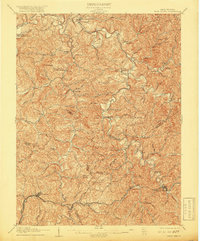
Middle Island Creek carves a winding course through this section of northern West Virginia, defined by the intricate topography of the Allegheny Plateau as it appeared at the turn of the century. The southern portion of the map is anchored by the Baltimore and Ohio RR, which parallels the Northwestern Virginia Turnpike through Pennsboro and West Union. These vital transportation corridors supported a network of small settlements and post offices such as Central Station and Little PO.
Find a feature on this map
82 named features on this map. Tap any name to fly to it.
Don’t see what you’re looking for? This feature index may not catch every label — zoom into the map to look around manually.
Map Details
Editions of this 1905 West Union Map
2 editions found
Other maps of this area

1903 · Littleton
USGS Topo · 1:62,500

1904 · Vadis
USGS Topo · 1:62,500

1905 · Centerpoint
USGS Topo · 1:62,500

1905 · West Union
USGS Topo · 1:62,500

1905 · Littleton
USGS Topo · 1:62,500

1905 · New Matamoras
USGS Topo · 1:62,500

1906 · Saint Marys
USGS Topo · 1:62,500

1906 · Holbrook
USGS Topo · 1:62,500

1906 · New Martinsville
USGS Topo · 1:62,500

1907 · Harrisville
USGS Topo · 1:62,500