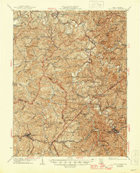
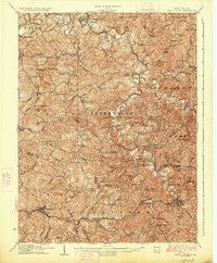
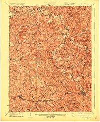
1926 Map of West Union
USGS Topo · Published 1945About this map
Middlebourne and West Union anchor this topographic study of the West Virginia panhandle region, capturing a landscape of deeply incised valleys and ridge-top settlements during the mid-1920s. The Baltimore and Ohio railroad corridor through the southern half of the sheet connects towns like Pennsboro, Greenwood, and Tollgate, serving as the primary industrial artery for the region.
Find a feature on this map
128 named features on this map. Tap any name to fly to it.
Don’t see what you’re looking for? This feature index may not catch every label — zoom into the map to look around manually.
Map Details
Editions of this 1926 West Union Map
3 editions found
Other maps of this area

1903 · Littleton
USGS Topo · 1:62,500

1904 · Vadis
USGS Topo · 1:62,500

1905 · Centerpoint
USGS Topo · 1:62,500

1905 · West Union
USGS Topo · 1:62,500

1905 · Littleton
USGS Topo · 1:62,500

1905 · New Matamoras
USGS Topo · 1:62,500

1906 · Saint Marys
USGS Topo · 1:62,500

1906 · Holbrook
USGS Topo · 1:62,500

1906 · New Martinsville
USGS Topo · 1:62,500

1907 · Harrisville
USGS Topo · 1:62,500