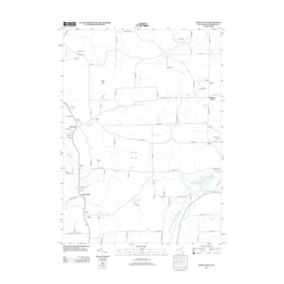
2013 Map of West Valley
USGS Topo · Published 2013About this map
West Valley serves as a primary hub in this corner of Cattaraugus County, situated near the headwaters of Buttermilk Cr and Indian Cr. The surrounding landscape is defined by the modest elevations of Bread Loaf Hill and Burns Hill, with a network of rural roads connecting scattered settlements and family-named landmarks. Near the southern edge, the Beaver Siding rail feature and a cluster of burial grounds, including Mt Hope Cem and Saint Johns Cem, mark the historical community footprints in the valley. Moving north, the map reveals Riceville and the distinctively named McKinstry Hollow along the winding course of Gooseneck Cr. This 2013 survey provides a clear view of the area's transition from open farmland to small crossroads like Brewer Corners, preserving the names of local landmarks such as The Moore the Merrier Farm and numerous country cemeteries that offer valuable clues for genealogical research.
Find a feature on this map
89 named features on this map. Tap any name to fly to it.
Don’t see what you’re looking for? This feature index may not catch every label — zoom into the map to look around manually.
Map Details
Editions of this 2013 West Valley Map
This is the sole edition of this map. No revisions or reprints were ever made.
Other maps of this area

1923 · Arcade
USGS Topo · 1:62,500

1924 · Ellicottville
USGS Topo · 1:62,500

1924 · Franklinville
USGS Topo · 1:62,500

1925 · Springville
USGS Topo · 1:62,500

1925 · Arcade
USGS Topo · 1:62,500

1941 · Ellicottville
USGS Topo · 1:62,500

1942 · Franklinville
USGS Topo · 1:62,500
1954 · Springville
USGS Topo · 1:24,000

1957 · Sardinia
USGS Topo · 1:24,000

1960 · Buffalo
USGS Topo · 1:250,000