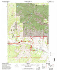
1996 Map of West Valley
USGS Topo · Published 1998About this map
The rugged boundary between Granite and Deer Lodge counties is defined by intense mineral exploration and the transition from mountain ridges to the West Valley floor. In the northern reaches, Lost Creek State Park sits adjacent to heavy prospecting activity near Thornton Ridge and Olson Mountain. The landscape is carved by numerous drainages, most notably Blue Eyed Nellie Gulch and Stucky Gulch, which flow toward the more developed lowlands. Near the settlement of Stump Town, the valley floor shows the infrastructure of the late 20th century, including the local Drive-in Theater and Hatcher Field. This area, heavily integrated into the Deerlodge National Forest, reflects a legacy of extraction, with numerous unnamed Mines and Prospects dotting the slopes of Garrity Mountain above the path of Warm Springs Creek.
Find a feature on this map
36 named features on this map. Tap any name to fly to it.
Don’t see what you’re looking for? This feature index may not catch every label — zoom into the map to look around manually.
Map Details
Editions of this 1996 West Valley Map
This is the sole edition of this map. No revisions or reprints were ever made.
Other maps of this area

1889 · Helena
USGS Topo · 1:250,000

1893 · Helena
USGS Topo · 1:250,000

1899 · Helena
USGS Topo · 1:250,000

1903 · Helena
USGS Topo · 1:250,000

1908 · Philipsburg
USGS Topo · 1:125,000

1947 · Butte
USGS Topo · 1:250,000

1958 · Butte
USGS Topo · 1:250,000

1960 · Butte
USGS Topo · 1:250,000

1961 · Anaconda
USGS Topo · 1:62,500

1962 · Butte
USGS Topo · 1:250,000