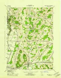
1945 Map of West Winfield
USGS Topo · Published 1945About this map
The Unadilla River headwaters and the rolling hills of the New York interior define this mid-1940s landscape, captured by the Corps of Engineers and Tennessee Valley Authority. The map centers on the concentrated settlement of West Winfield, where the Lackawanna RR and the historic Turnpike intersect. This region, spanning the borders of Oneida, Herkimer, and Otsego counties, preserves a detailed record of rural social infrastructure through its many numbered schoolhouses, such as School No 5 and School No 8, and numerous family and community burial grounds including Bardin Cem and Gird Cem. To the west, the Bridgewater Flats provide a level corridor for the Lackawanna and Western RR as it passes through North Bridgewater. The terrain is punctuated by significant rises like Wheelock Hill and Jerusalem Hill, while local water bodies like Cedar Lake and Kibby Pond serve as landmarks in this late-war era survey.
Find a feature on this map
46 named features on this map. Tap any name to fly to it.
Don’t see what you’re looking for? This feature index may not catch every label — zoom into the map to look around manually.
Map Details
Editions of this 1945 West Winfield Map
This is the sole edition of this map. No revisions or reprints were ever made.
Other maps of this area

1895 · Oriskany
USGS Topo · 1:62,500

1898 · Utica
USGS Topo · 1:62,500

1898 · Oriskany
USGS Topo · 1:62,500

1900 · Utica
USGS Topo · 1:62,500

1907 · Winfield
USGS Topo · 1:62,500

1907 · Sangerfield
USGS Topo · 1:62,500

1943 · Schuyler Lake
USGS Topo · 1:24,000

1943 · Utica East
USGS Topo · 1:24,000

1943 · Millers Mills
USGS Topo · 1:24,000

1943 · Cassville
USGS Topo · 1:24,000