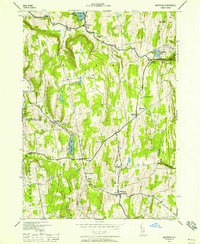
1943 Map of Westerlo
USGS Topo · Published 1958About this map
The Helderberg Mountains dominate this 1943 survey, shaping the drainage and settlement patterns of southern Albany County. Water flows through the highlands via Fox Creek, Basic Creek, and Hannacrois Cr, while the landscape is dotted with early 20th-century recreational sites like Camp Orinsekwa and Camp Woodstock on the shores of Warner Lake. The map reveals a high density of rural schoolhouses and family-named crossroads common to the Catskill foothills, including Benson's Corners and Snyders Cors. Significant local history is preserved in the locations of the Reidsville Cem and Snyder Cem, alongside the remote Partridge Run Game Management Area. The prominence of the Radio Towers (Sta WZXI) near Wolf Hill provides a modern industrial contrast to the traditional agricultural settlements of Westerlo and East Berne.
Find a feature on this map
40 named features on this map. Tap any name to fly to it.
Don’t see what you’re looking for? This feature index may not catch every label — zoom into the map to look around manually.
Map Details
Editions of this 1943 Westerlo Map
3 editions found
Other maps of this area

1893 · Coxsackie
USGS Topo · 1:62,500

1893 · Durham
USGS Topo · 1:62,500

1893 · Albany
USGS Topo · 1:62,500

1894 · Coxsackie
USGS Topo · 1:62,500

1894 · Durham
USGS Topo · 1:62,500

1895 · Albany
USGS Topo · 1:62,500

1898 · Albany
USGS Topo · 1:62,500

1900 · Berne
USGS Topo · 1:62,500

1903 · Berne
USGS Topo · 1:62,500

1927 · Albany
USGS Topo · 1:62,500