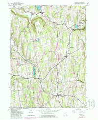
1943 Map of Westerlo
USGS Topo · Published 1988About this map
The Helderberg Mountains rise sharply across the eastern landscape of this 1943 survey, shaping the rural development of Albany County. This terrain is defined by a network of crossroad hamlets, including Bensons Corners, Mallorys Corners, Snyders Cors, and Bramans Corners, each serving as a focal point for local agricultural commerce. The presence of numerous small burying grounds, such as the Reidsville Cem, Westerlo Cem, and Snyder Cem, offers significant evidence for genealogists tracing family lineages in the Westerlo and Rensselaerville townships. Natural water features like Warner Lake and Helderberg Lake suggest the area's role as a seasonal retreat, supported by the appearance of Camp Orinsekwa and Camp Woodstock. Large tracts of conserved land are also mapped, including the Partridge Run Game Management Area, illustrating the 20th-century shift toward forest management and public recreation.
Find a feature on this map
39 named features on this map. Tap any name to fly to it.
Don’t see what you’re looking for? This feature index may not catch every label — zoom into the map to look around manually.
Map Details
Editions of this 1943 Westerlo Map
3 editions found
Other maps of this area

1893 · Coxsackie
USGS Topo · 1:62,500

1893 · Durham
USGS Topo · 1:62,500

1893 · Albany
USGS Topo · 1:62,500

1894 · Coxsackie
USGS Topo · 1:62,500

1894 · Durham
USGS Topo · 1:62,500

1895 · Albany
USGS Topo · 1:62,500

1898 · Albany
USGS Topo · 1:62,500

1900 · Berne
USGS Topo · 1:62,500

1903 · Berne
USGS Topo · 1:62,500

1927 · Albany
USGS Topo · 1:62,500