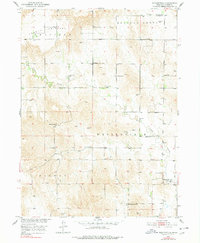
1974 Map of Westerville
USGS Topo · Published 1978About this map
Westerville and the surrounding Nebraska ranchlands appear in this survey, showcasing a community defined by its proximity to Clear Creek and the expansive French Tableland to the north. This mid-century view, photoinspected in the 1970s, reveals a dispersed rural society anchored by a dense network of country schools, including Weissert Sch, Copsey Sch, and Hanna Corners Sch. These school districts, often paired with localized cemeteries like Lone Tree Cem and Dry Valley Cem, provide a precise record of the family-centered geography of Custer County during this era.
Find a feature on this map
19 named features on this map. Tap any name to fly to it.
Don’t see what you’re looking for? This feature index may not catch every label — zoom into the map to look around manually.
Map Details
Editions of this 1974 Westerville Map
This is the sole edition of this map. No revisions or reprints were ever made.
Other maps of this area

1951 · Broken Bow NE
USGS Topo · 1:24,000

1951 · Westerville
USGS Topo · 1:24,000

1951 · Ansley
USGS Topo · 1:24,000

1951 · Broken Bow SE
USGS Topo · 1:24,000

1951 · Ansley NE
USGS Topo · 1:24,000

1951 · Round Valley
USGS Topo · 1:24,000

1951 · Ansley SE
USGS Topo · 1:24,000

1952 · Sargent SE
USGS Topo · 1:24,000

1952 · Sargent SW
USGS Topo · 1:24,000

1955 · Broken Bow
USGS Topo · 1:250,000