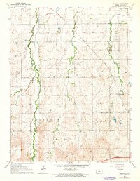
1963 Map of Westfall
USGS Topo · Published 1964About this map
The Atchison Topeka and Santa Fe railroad cuts a diagonal path through this Lincoln County landscape, linking the small communities of Westfall and Edalgo. This 1963 field-checked survey reveals a rural economy shaped by a network of waterways including Elkhorn Creek, Owl Creek, and Brush Creek. The map provides significant genealogical value, documenting early burial grounds such as Washam Cem, Hammer Cem, and the St Pauls Cemetery located near St Pauls Church.
Find a feature on this map
22 named features on this map. Tap any name to fly to it.
Don’t see what you’re looking for? This feature index may not catch every label — zoom into the map to look around manually.
Map Details
Editions of this 1963 Westfall Map
This is the sole edition of this map. No revisions or reprints were ever made.
Other maps of this area

1892 · Salina
USGS Topo · 1:125,000

1892 · Minneapolis
USGS Topo · 1:125,000

1894 · Ellsworth
USGS Topo · 1:125,000

1894 · Beloit
USGS Topo · 1:125,000

1942 · Salina
USGS Topo · 1:125,000

1955 · Manhattan
USGS Topo · 1:250,000

1955 · Great Bend
USGS Topo · 1:250,000

1955 · Hutchinson
USGS Topo · 1:250,000

1955 · Beloit
USGS Topo · 1:250,000

1956 · Manhattan
USGS Topo · 1:250,000