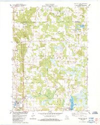
1984 Map of Westfield East
USGS Topo · Published 1984About this map
Westfield and the neighboring village of Harrisville anchor this mid-1980s look at the central Wisconsin landscape. The terrain is defined by a dense network of waterways, including the winding Chaffee Creek, Tagatz Creek, and Duck Creek, which flow through a mix of marshland and agricultural fields. Local genealogy is well-preserved through several family and community landmarks, such as Krentz Cem, Newton Ch Cem, and the Township Cem located just off Springfield drive.
Find a feature on this map
48 named features on this map. Tap any name to fly to it.
Don’t see what you’re looking for? This feature index may not catch every label — zoom into the map to look around manually.
Map Details
Editions of this 1984 Westfield East Map
This is the sole edition of this map. No revisions or reprints were ever made.
Other maps of this area

1955 · Green Bay
USGS Topo · 1:250,000

1957 · Madison
USGS Topo · 1:250,000

1958 · Coloma
USGS Topo · 1:48,000

1959 · Wautoma
USGS Topo · 1:48,000

1960 · Madison
USGS Topo · 1:250,000

1961 · Oxford
USGS Topo · 1:62,500

1961 · Montello
USGS Topo · 1:62,500

1968 · Coloma
USGS Topo · 1:24,000

1968 · Richford
USGS Topo · 1:24,000
1968 · Wautoma
USGS Topo · 1:24,000