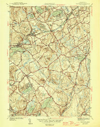
1946 Map of Westford
USGS Topo · Published 1946About this map
Forge Village and Graniteville anchor this mid-1940s landscape, illustrating the industrial and residential development concentrated along the Boston and Maine Railroad corridors. The terrain is defined by a series of prominent glacial hills, including Nashoba Hill, Millstone Hill, and Kissacook Hill, which dictate the winding paths of roads like Snake Meadow Rd and Hartford Rd. Large bodies of water such as Forge Pond, Nagog Pond, and Nabnasset Pond are prominent, while smaller features like Tadmuck Swamp and Sought for Pond offer insight into the natural drainage of the area before modern suburban expansion.
Find a feature on this map
105 named features on this map. Tap any name to fly to it.
Don’t see what you’re looking for? This feature index may not catch every label — zoom into the map to look around manually.
Map Details
Editions of this 1946 Westford Map
2 editions found
Other maps of this area

1886 · Lowell
USGS Topo · 1:62,500

1886 · Framingham
USGS Topo · 1:62,500

1887 · Marlboro
USGS Topo · 1:62,500

1889 · Marlboro
USGS Topo · 1:62,500

1889 · Framingham
USGS Topo · 1:62,500

1893 · Lowell
USGS Topo · 1:62,500

1893 · Groton
USGS Topo · 1:62,500

1894 · Framingham
USGS Topo · 1:62,500

1896 · Marlboro
USGS Topo · 1:62,500

1898 · Marlboro
USGS Topo · 1:62,500