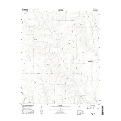
2016 Map of Weston
USGS Topo · Published 2016About this map
Weston and Chambersville serve as the primary nodes of settlement in this part of north-central Collin County, where the agricultural past meets modern rural development. The landscape is defined by the winding course of the E Fork Trinity River in the northeast and a network of seasonal streams including Honey Cr, Stover Cr, and Franklin Br. This hydrologic pattern influenced the placement of early homesteads and cemeteries, many of which remain visible as small island-like clearings on the modern landscape. Genealogists can locate several local burial grounds such as Mugg Cem, Franklin Cem, and Wilson Cem. To the south, the expansive Erwin Park provides a transition from the agricultural plains toward the growing outskirts of McKinney. The road network, comprising established routes like W FM 455 and numerous county roads such as Twin Bridges Rd, follows the section lines and topography of the Blackland Prairie.
Find a feature on this map
112 named features on this map. Tap any name to fly to it.
Don’t see what you’re looking for? This feature index may not catch every label — zoom into the map to look around manually.
Map Details
Editions of this 2016 Weston Map
This is the sole edition of this map. No revisions or reprints were ever made.
Other maps of this area

1929 · Frisco
USGS Topo · 1:62,500

1929 · McKinney
USGS Topo · 1:62,500

1954 · Sherman
USGS Topo · 1:250,000

1958 · Sherman
USGS Topo · 1:250,000

1960 · Frisco
USGS Topo · 1:24,000

1960 · McKinney East
USGS Topo · 1:24,000

1960 · Celina
USGS Topo · 1:24,000
1960 · McKinney West
USGS Topo · 1:24,000

1961 · Gunter
USGS Topo · 1:24,000

1961 · Van Alstyne
USGS Topo · 1:24,000