
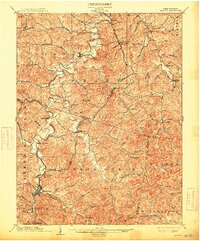
1904 Map of Weston
USGS Topo · Published 1904About this map
Weston serves as the central hub of this 1904 survey, situated at the junction of the Baltimore and Ohio RR and the West Fork River. The landscape is a network of ridges and deep drainage valleys defined by waterways like Hackers Creek and Freeman Creek. Settlement is concentrated along these river corridors and rail lines, with small communities such as Jane Lew and Lost Creek established near the tracks. North of Mount Clare Byron Sta, the Lynch Mines indicate the early industrial activity in the region, while rural centers like Romines Mills and Sycamore Dale highlight a dispersed agricultural and milling economy. This record captures the region shortly after the turn of the century, showing the specific locations of the Dovener P.O. Dean and landmarks such as Jackson Mill.
Find a feature on this map
76 named features on this map. Tap any name to fly to it.
Don’t see what you’re looking for? This feature index may not catch every label — zoom into the map to look around manually.
Map Details
Editions of this 1904 Weston Map
2 editions found
Other maps of this area

1893 · Buckhannon
USGS Topo · 1:125,000

1893 · Sutton
USGS Topo · 1:125,000

1896 · Buckhannon
USGS Topo · 1:125,000

1897 · Buckhannon
USGS Topo · 1:125,000

1902 · Clarksburg
USGS Topo · 1:62,500

1902 · Fairmont
USGS Topo · 1:62,500

1904 · Philippi
USGS Topo · 1:62,500

1904 · Vadis
USGS Topo · 1:62,500

1905 · Centerpoint
USGS Topo · 1:62,500

1906 · Burnsville
USGS Topo · 1:62,500