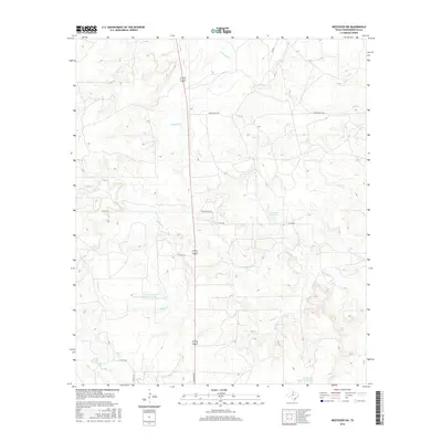
2016 Map of Westover SW
USGS Topo · Published 2016About this map
The Texas A and M Experimental Ranch Lake serves as a central landmark in this portion of Throckmorton County, illustrating the intersection of academic research and the Texas ranching landscape. The terrain is defined by a dense network of seasonal drainages, including the various branches of Boggy Creek and the winding course of Wagon Creek. These waterways dictate the local geography, carving through the ranchlands where names like Spade Ranch Rd point to the area's agricultural heritage. Small reservoirs and livestock tanks, such as Timmons Lake and Patterson Lake Number 2, are scattered across the landscape, highlighting the critical importance of water management in this cattle-country environment. The infrastructure is primarily composed of rural county roads and ranch access routes, maintaining the open, working character of the North Texas plains.
Find a feature on this map
18 named features on this map. Tap any name to fly to it.
Don’t see what you’re looking for? This feature index may not catch every label — zoom into the map to look around manually.
Map Details
Editions of this 2016 Westover SW Map
This is the sole edition of this map. No revisions or reprints were ever made.
Other maps of this area

1954 · Wichita Falls
USGS Topo · 1:250,000

1958 · Wichita Falls
USGS Topo · 1:250,000

1962 · Antelope Creek SE
USGS Topo · 1:24,000

1962 · Antelope Creek NE
USGS Topo · 1:24,000

1965 · Throckmorton NE
USGS Topo · 1:24,000

1966 · Westover SE
USGS Topo · 1:24,000

1966 · Rock Canyon
USGS Topo · 1:24,000

1966 · Westover SW
USGS Topo · 1:24,000

1966 · Tonk Creek
USGS Topo · 1:24,000
1966 · Throckmorton
USGS Topo · 1:24,000