
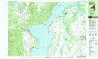
1980 Map of Westport
USGS Topo · Published 1981This historical map portrays the area of Westport in 1980, primarily covering Essex County as well as portions of Essex County and Vermont. Featuring a scale of 1:25000, this map provides a highly detailed snapshot of the terrain, roads, buildings, counties, and historical landmarks in the Westport region at the time. Published in 1981, it is one of 3 known editions of this map due to revisions or reprints.
Find a feature on this map
103 named features on this map. Tap any name to fly to it.
Don’t see what you’re looking for? This feature index may not catch every label — zoom into the map to look around manually.
Map Details
Editions of this 1980 Westport Map
3 editions found
Historical Maps of Waltham Through Time
58 maps found

1894 Elizabethtown
Essex County, NY

1894 Port Henry
Essex County, NY

1895 Ausable
Essex County, NY

1895 Elizabethtown
Essex County, NY

1895 Mt. Marcy
Essex County, NY

1895 Paradox Lake
Essex County, NY

1895 Willsboro
Essex County, NY

1897 Paradox Lake
Essex County, NY

1898 Newcomb
Essex County, NY

1898 Port Henry
Essex County, NY

1901 Elizabethtown
Essex County, NY

1901 Newcomb
Essex County, NY

1902 Mt. Marcy
Essex County, NY

1903 Ausable
Essex County, NY

1904 Santanoni
Essex County, NY

1941 Willsboro
Essex County, NY

1943 Willsboro
Essex County, NY

1945 Port Henry
Essex County, NY

1947 Port Henry
Essex County, NY

1950 Crown Point
Essex County, NY

1950 Lake Champlain
Essex County, NY

1950 Ticonderoga
Essex County, NY

1953 Mount Marcy
Essex County, NY

1953 Paradox Lake
Essex County, NY

1953 Santanoni
Essex County, NY

1954 Newcomb
Essex County, NY

1955 Elizabethtown
Essex County, NY

1956 Willsboro
Essex County, NY

1958 Lake Champlain
Essex County, NY

1962 Lake Champlain
Essex County, NY

1973 Eagle Lake
Essex County, NY

1973 Graphite
Essex County, NY

1973 Paradox Lake
Essex County, NY

1973 Pharaoh Mountain
Essex County, NY

1978 Elizabethtown
Essex County, NY

1978 Lewbeach
Essex County, NY

1978 Wilmington
Essex County, NY

1979 Keene Valley
Essex County, NY

1979 Mount Marcy
Essex County, NY

1979 Santanoni Peak
Essex County, NY

1980 Port Henry
Essex County, NY

1980 Westport
Essex County, NY

1980 Willsboro Bay
Essex County, NY

1980 Willsboro
Essex County, NY

1986 Lake Champlain South
Essex County, NY

1986 Ticonderoga
Essex County, NY

1989 Blue Ridge
Essex County, NY

1989 Dutton Mountain
Essex County, NY

1989 Newcomb
Essex County, NY

1989 Ticonderoga
Essex County, NY

1997 Dutton Mountain
Essex County, NY

1997 Newcomb
Essex County, NY

1999 Keene Valley
Essex County, NY

1999 Lewis
Essex County, NY

1999 Mount Marcy
Essex County, NY

1999 Santanoni Peak
Essex County, NY

1999 Westport
Essex County, NY

1999 Willsboro
Essex County, NY